

Section 3 is 126.7 miles long and runs from Benchmark Ranch to Highway 12, the access point to Helena, Montana. July 8th - 15th.
Day 15, 0-day in Augusta, Montana.
I walked back to town in the morning to grab my food resupply and then stopped by the van on my way back to say goodbye. Papa Oats also had a spare pair of trekking poles and let me have one of the tips since I had just broke one in The Bob. Then I spent a nice 10 hours or so laying in bed, editing photos, talking to Sea Lion, and mostly ignoring a trio of terrible movies I had playing in the background. Throughout the day I intermittently ate some Greek yogurt with raspberries or my leftover pizza and it felt great. This is what all 0-days should be like! I had planned to meet Simba and some other hikers for dinner but when I opened the door to leave it was pouring down rain. I waited on the porch in a comfy rocking chair to see if it would pass but it just got worse so I went inside and finished off my pizza instead.
My home for two nights.
Day 16, 11.4 miles to Straight Creek.
I met Simba for breakfast and with him were Fidget and Rafiki who didn't believe I was a real person after I ghosted them last night at dinner. We ate some delicious brekkie at Mel's Cafe and nerded out about gear, miles, and trail stories for a bit before disbanding. I returned to the Wagon West to pack up and check out then went to the American Legion Park where Simba had camped. On the way down, I met a guy named Frank who said he could give a load of hikers a ride back to Benchmark in about an hour. I passed the news on to Simba but he said he still had too many chores to do and probably couldn't make it. I waited at the road around that hour mark but Frank never showed up. Then I ran into Jake and Artemis who are also ready to get back on trail and we walked to the edge of town where the dirt road starts and threw out our thumbs. We soon got a ride from a guy who has been piecing together the CDT for the past few years. He was on his way to retrieve a food drop from Benchmark Ranch since it had delicious homemade jerky that he didn't want to part with. I hopped on the trail, and they were the last people I saw for almost two whole days. I had a steady but gentle up till climb for most of the day that was topped off with a 1000ft up and down over Elbow Pass. I found a perfect campsite at the bottom next to the Straight Creek with two good hammock trees directly next to the rushing water, a fire pit, and plenty of firewood. I set up camp, made a fire, dined alone, and read The Indifferent Stars Above until dark.
Mountain Bog Gentians.
Great campsite next to Elbow Creek.
Day 17, 20.9 miles to camp at mile 266.4.
I forded the icy water of the creek to start my day and then the next 17 miles followed the Straight Creek, Welcome Creek, and Deerborn River before beginning the climb up to the ridge. There were a few pointless river crossings (or PRF's, similar to PUD's, Pointless Up and Downs) so I elected to stay on one side of the water and make my own trail. It was mostly burned forests so bushwhacking was minimal and I could walk on fallen tree trunks. I went for a quick dip in the clear cool waters of Pear Creek and took a nap alongside Deerborn River which had an excellently maintained stretch of trail. I ate dinner at the base of a massive 3,200ft climb that I planned to break into two days. Luckily there was water and some campsites halfway up the ascent. I hung my hammock, did some more reading until sunset, and realized I hadn't seen a single human since beginning this section about 30 hours ago.
The small pass I climbed over and was greeted by Welcome Creek.
Finally moving up in the world!
Day 18, 19.7 miles to a Spring on Green Mountain.
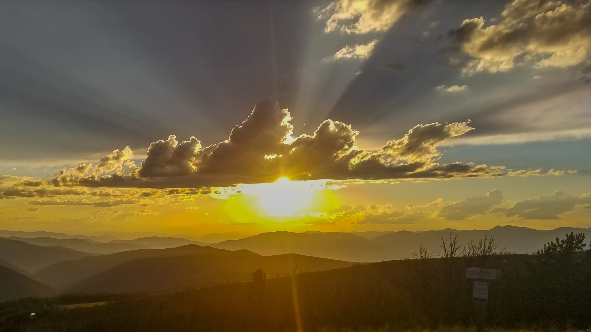
I woke up in time to catch the sun peaking out from behind a mountain, for some photo, and hit the trail nice and early to finish this climb. The rest of the day would be hiking along a gorgeous ridgeline that is the actual Continental Divide, not just on a trail near it. The views were breathtaking and I was constantly firing up my PeakFinder App to learn the names of all the mountains surrounding the trail. There was a steep down and up to a lake which was the only water source for the day. I loved seeing all of the peaks instead of burned trees in low river valleys but the trade off was long water carried and tons of sunlight. I'm glad I still have my super-shade hat from the PCT. The ridgelines were blooming with tons of colorful Alpine wildflowers; Columbines, Forget-Me-Nots, Creeping Cinquefoils, and Subalpine Fleabanes. Back on top of the ridge I was treated with more amazing views and cool bubbly rocks formations the lined the edge of the ridge. I tackled the gruelingly steep 1,000ft climb over one mile to get passed Green Mountain and to a spring at the end of a 13-mile waterless stretch. There were two live trees next to the spring, in the middle of a field, which were inviting me to hammock on. As I ate dinner I saw the clouds explode with a deep pink light from the sunset and part of me I wished I camped on the other side of Green Mountain to see the show.
Sunrise from camp.
Red Mountain and Pyramid Peak.
More elevation gain.
Columbines.
Can you see the trail winding to that second peak?
Cairn atop that second peak from previous photo.
Bubbly rocks dotted the edge of the next section of ridge.
I felt like I was a short guy in the back row of a concert.
Day 19, 17.2 miles to camp at marker 322.4 plus a pitstop in Lincoln, Montana.
I first had an easy few miles to Highway 200 to hitch in to Lincoln and on the way I saw some new wildflowers and a yurt used for some sort of bird observations, but it was locked up. In town, I stopped to get my food resupply at a little market and then went across the street for a burger at the Wilderness Bar. I scored a hitch back up to Rogers Pass and took a break at the stream which marked the beginning of another long water carry. I cameled up by chugging 2L and then blasted up the climb back to the dividing ridge. The beating sun and open ridge wore me out and I wound up having to hike a few extra miles more than planned to find trees. I crossed 300 miles on the trail and towards the end of the day, came across a nice 30ft tall rock wall so I climbed it. It had a slight slope so it was more of a scramble than a vertical climb but it was fun nonetheless. Another mile afterwards I found two live trees that would hold my hammock but there was a log directly underneath. It crumbled when I went to move it and I saw an ant colony had taken up residence inside. So I left them be and made sure to hang all of my stuff from my hammock instead of leaving it on the ground for them to invade.
Primroses.
The tiny town of Lincoln was gearing up for a motorcycle rally over the weekend.
Their “Stinger Burger” was delicious.
Day 20, 19 miles to camp at marker 322.4.
I had a nice and early start to the day and was on trail at 7:30 sharp. After a gentle downhill start to the day I arrived at Flesher Pass which has a nice cold creek flowing 0.3 off trail. I cooked a disgusting instant cheesy-lasagna dehydrated meal for breakfast and had to choke it down with some Doritos. Back up at the trailhead I met some mountain bikers and chatted with them for a few minutes before setting back off in the woods. They caught up to me as I was taking a break and then I leapfrogged them when they stopped at the top of a hill. They decided that was enough work pedaling up there and it was time to turn around for the fun part, flying downhill. A bit further along I arrived at a dirt roadwalk that snakes around a Nordic ski area and took a snack break under a tree to wait out a light rain. I then hiked on to a stream and deep booming thunder began creeping my way so I decided to book it to a parking area with a privy. Privies have porches which are great shelters for passing rains. After that I took a road walk up to the Granite Butte Lookout Tower and along the way an old bearded man pulled up in a minivan and handed me a beer for the road. The tower was locked up but had some vehicles parked nearby and coolers and chairs up on the deck. I was definitely going to wait for sunset up here and hoped the occupants of the tower didn't mind. I sewed up some holes in my gaiters and clothes, ate dinner, talked with Sea Lion on the phone, and set the timelapse which turned out phenomenal! The tower occupants arrived on an ATV and offered me yet another beer. Today has been great. Shortly after the sunset concluded, a massive lightnight storm arrived and I practically ran off of the hill and into tree cover. I frantically set my tarp and hammock in the rain but of course the precipitation stopped as soon as I was all set up.
Purple Monkeyflower. My favorite flower name ever!
Granite Butte Lookout Tower. You can rent it out for the weekend.
Prints Available!
Sun rays before sunset.
Day 21, 16.2 miles to marker 338.6.
The thunder returned at 3:30am or so and kept me awake for an hour. It departed the area just in time for sunrise and squawking birds which kept me awake even longer. When they stopped, I managed to get some shut-eye for a bit and didn't make it into the trail until 11:00am. After a few easy miles I hit the junction to Nevada Creek which was a few hundred feet down in elevation and a half mile off trail. I chomped down some pepperoni, cheese, & crushed Doritos burritos and cameled some more water before hiking back to trail and then another 1,000ft climb up. There was a ton of elevation on this stretch and it really tuckered me out. After a few more ups and downs I felt a shin splints coming on so I took a long break at the top of the last climb for the day. I planned to camp as soon as I found some good trees at the bottom after I filled up on water at a cow trough. I met Yukon and Clementine there who told me about an upcoming alternate route which takes some dirt roads to skip a few miles of trail with endless blowdowns. They took off and then I met Cargo who hiked with me another mile until I set up shop. After hanging my hammock, a massive wind kicked up that filled it like a sail and I knew I had to move. Staying put would lead to a cold night and terrible sleep. I had already inflated my mattress so I just carried it from both ends like a giant satchel.
View from my nap spot.
Mmmm, cow slobber and water.
Day 22, 17.9 miles to MacDonald Pass and a hitch into Helena, MT.
I woke up as Simba was hiking by, he had stayed a night in Lincoln to people-watch all of the bikers, and I soon got packed and hit the trail. It was a great day to cruise along the flat dirt roads surrounded by cows and rolling hills. I took a wrong turn at one point and decided to just follow the trail since they all spider-web together and connect eventually. My road abruptly disappeared I to nothing in a huge field. I was determined not to backtrack so I stayed heading south and found the real road soon enough, only it was on the other side of a barbed wire fence. So I hopped it and was on my way. I caught up with Simba, joined him for lunch, and then hiked the rest of the roadwalk together. He noticed a bumblebee that impaled his face on a Barb on the fence and his body was left hanging there. It was metal. After we rejoined the CDT, Simba took off as I stopped to take photos of a super old and abandoned railroad bridge. Further up the trail I came across a falling apart cabin that had a sign with the barely legible word “economic” on it. I figured it was some outpost for the old railway.
After the big climb, it was a gravel road down to Highway 12 which allowed for some more cruising but then we had to walk along the highway for 0.7 to McDonald Pass for a safe spot to hitch. A PCT'er from 2012, Gutfeeling, scooped us up in her Subaru. On the way to town we learned the Budget Inn, the cheapest option and most frequented for hikers was full and as we began searching for an alternative, she said she had to pick up her kid from daycare. Her kid was a 6 month old girl who was placed in the car seat next to me and Gutfeeling tossed me a bottle while saying “you're on feeding duty! That's your price for the ride.” Wow. I've never fed a baby before, let alone a stranger's baby, in a car, while hitchhiking. We stopped atBudget Inn so I could grab my new shoes which wereshipped there and then went to the Hilton. Luxury. We are at a delicious bar called the Windbag Saloon and more groups of hikers kept showing up and joining our table.
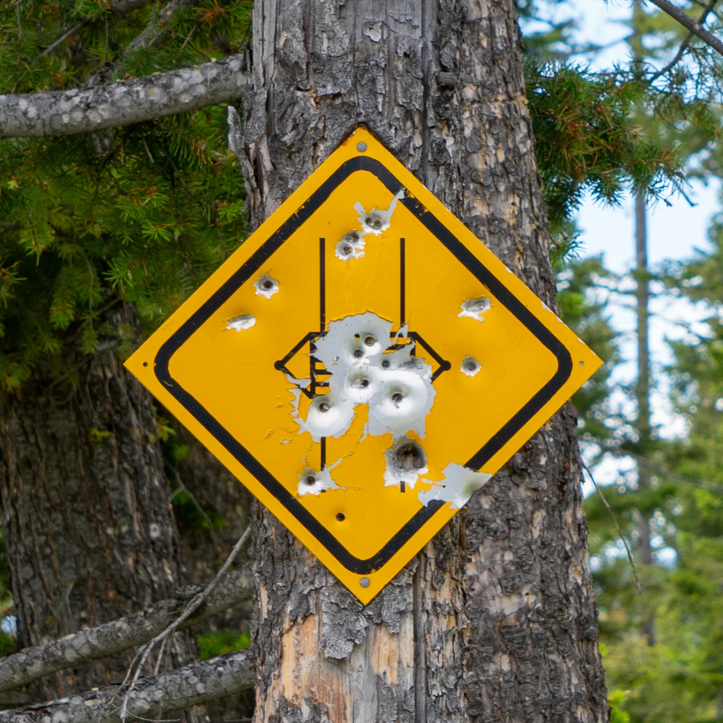
You know you're in the country when…