
“The Bob” picks up where Glacier NP ends and runs for 134 miles to Benchmark Campgrounds. July 2nd - 7th.
Day 8, 0-day in East Glacier Village.
I was hoping to be able to check in early and have a bed to rest in the horizontal position, but they would not let me do so until 3PM. So I spent most of the day hanging out on the porch with other hikers and working on my blog. I made a quick trip into town to mail home my microspikes, pick up dinner to cook, and then returned to check in. I ate an entire bag of cheese ravioli for dinner and then I had a video chat date with Sea Lion. However, the Wi-Fi was not strong enough in my room so I again took to the porch. I tried to go to bed early, but Brownie's has paper thin walls so the chatter of other hikers kept me up for awhile. I wished I just hammocked across the street again and saved some money.
Day 9, 15.2 mile “slackpack” to East Glacier Village.
During my recent hangouts with other hikers, I learned that I completely missed the international boundary monument at Chief Mountain. I knew that it would eat me up for the rest of the hike if I did not go back to the official start point and touch the US-Canada border. So I decided to hitchhike back to the start, get some pictures, and hike that couple hundred yards before continuing on my journey. I quickly scored a ride with Penny and Auggy, two locals who grew up on the neighboring Blackfoot Reservation. They were just driving around for the day and were happy to take me and chat along the way. I learned that Penny was from a very traditional home and literally had to run away from home to attend college in Salt Lake City. After returning to my home base, Brownie's porch, I faced my next dilemma; hike out, stay and rest, or split the difference and “slackpack” 15 miles to the highway crossing. Slackpacking is when you leave most of your gear behind and hike a section with snacks and the bare essentials. I used to consider this cheating and lazy but all the other hikers were doing it! I also wouldn't make it to camp until way after dark if I had my full pack. So I hitched down highway 2 and flew back to East Glacier in 5 hours flat. I was glad to have been able to hitch up to Chief Mountain and back, then down highway 2 and hike back to still get some miles in on the day.
Auggy and Penny, thanks for the lift!
15.2 miles to go! 4:45 - 9:45
Day 10, 19.6 miles to Kip Creek.
I again walked back to the main part of town to score a hitch down highway 2 to start the trail where I left off. A white van pulled over and gave me a lift which is where I met Papa Oats and his girlfriend, Knife Hands. He is hiking the CDT and they built out the van so she could be the support vehicle and still spend time together. Papa Oats and I hiked this section together and I learned he is also 33, a former engineer, a hammocker, and on his Triple Crown hike. He had flipped twice already so he had a lot of tips about the sections in New Mexico and Wyoming. Anyway, we took a few alternate routes on this first day out because the official trail was absolutely littered with fallen trees. The trade-off was about a dozen river fords so I soon gave up on taking off my shoes to keep them dry. It also started to rain so it wouldve been a futile effort. Normally this is not a big deal because mesh trail runner shoes dry out quickly but I have Gortex shoes because I thought it'd still be snowy up here. Lesson learned. I had wet feet for most of this section. Most of today was spent hiking the alternate trails along the Two Medicine River and the North Badger Creek. Along the way we saw a miserable owl sitting on a rock who looked totally over the wet weather. We eventually arrived at Kip Creek which didn't have any tent spots but it offered plenty of trees just up the hill! The precipitation had ceased so we were able to set up our hammocks and meet down by the creek for dinner.
Day 11, 24.8 miles to Gooseberry Ranger Station.
We had a drying out party down by the creek but it was all for nothing since the trail was filled with overgrown vegetation that was still wet. It kept my shoes and pants soaked and put me in a bad mood to start off the day. After several miles I came to Elbow Creek which was clear of trees and the sun was on full blast so I dried out my things as best I could and took a quick snack break. I also started to rotate between two pairs of socks, one on my feet and one strapped to the top of my pack. This should help draw moisture out of my shoes. We met up at Beaver Lake for lunch but had to cut it short because it started to rain again. After 30-40 minutes it stopped and then we descended down into another burn zone. Hiking through burned forests is getting repetitive and old but least I got a cool shot of bright yellow Heartleaf Arnicas contrasting against the blackened soil and dead tree trunks. I took a break after fording Strawberry Creek and then again a few miles later to eat dinner. Pulling my biggest mile day yet was quite taxing and I slowly limped into the ranger station, set my hammock by the horse corral, and fell asleep hard. This ranger station is also at the start of a very popular alternate route called the Spotted Bear Alternate.
Nice color gradient on these Winter Vetches.
Heartleaf Arnicas decorating the forest floor.
Day 12, 20 miles to Spotted Bear River.
It is always nice to have a porch to eat a meal on. Especially when it rains for five minutes in the middle. The trail crosses Clack Creek and the light rain made the rocks just slippery enough for me to slip in when I tried to rock hop across. Another day of wet shoes. There were some good views of Trilobite Peak and Clack Mountain as we climbed out of the river valley and to the base of a huge cliff that I believed was a famous Montana feature called the Chinese Wall. During lunch I took a timelapse of clouds rolling by and then a lot of photos of Pentagon Mountain at the south end of the wall. The trail in real life and the trail line on my maps diverged so I wound up blazing my own way for most of the climb up Switchback Pass. Along the way I found a cool waterfall that looked like a staircase and a mountain named after me, Kevan Mountain. But I think they spelled it wrong. There was a long 2,600 foot drop after the pass but before going down you are treated with great views of Silvertip Mountain and Table Mountain. At the bottom I caught up to Papa Oats at the Pentagon River ranger station where we again had dinner on the porch. It was a great campsite, but there was still too much daylight left to stay put. We walked another four miles in the river valley which began to run into the same annoying issue of overgrown vegetation along both sides of the trail. The day was capped off with a ford across the Spotted Bear River where two sets of perfect hammock trees awaited us.
Distant peaks of Winter Points and Slideout Peak.
Dean Lake and Pentagon Mountain.
Kevan Mountain. I believe there was a spelling mistake.
Staircase Falls (I found it so I named it!)
Table Mountain.
Day 13, 21.2 miles to Sun River.
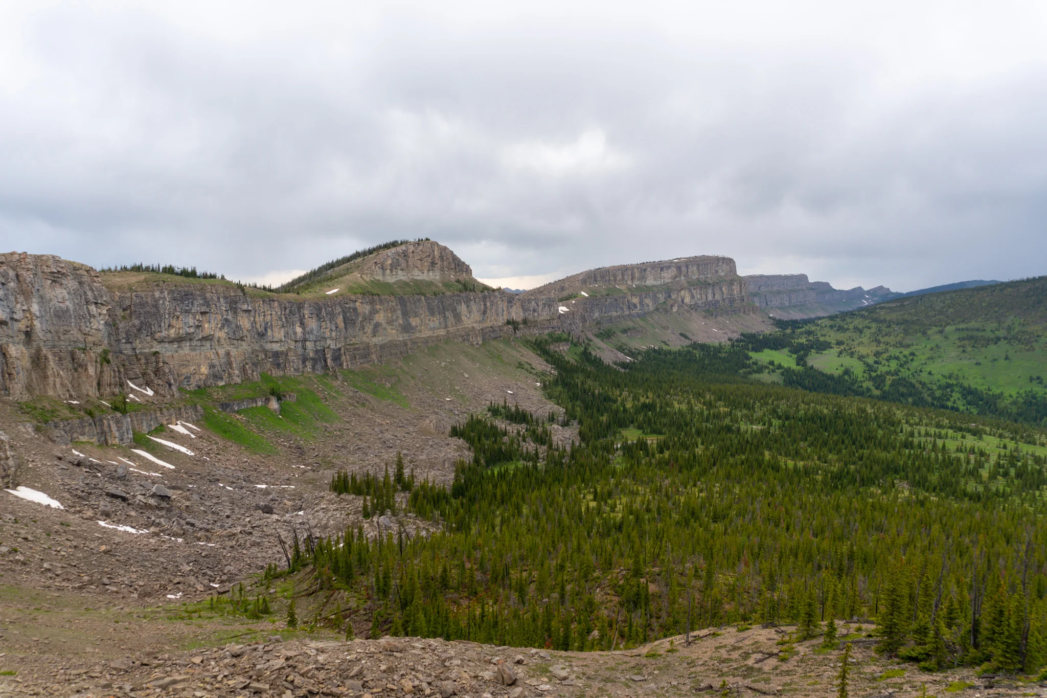
More wet shoes to start the day! The trail follows the river for quite a few miles, all with wet and overgrown vegetation crowding the sides. I couldn't wait to get back up along a ridgeline and out of this swamp. I took a break where the Spotted Bear Alternate rejoins the CDT and found a cool deer or elk skull. After some more elevation gain I arrived at the real Chinese Wall of Montana, easily three times larger than the wall from yesterday. Also, as I arrived at the start of the 6-mile long stretch along the base of the wall, it began to hail marbles. I took refuge under a tree and it was all over in a few minutes. Sunshine then poured into the valley for most of the hike and by the time I got to the South end it began to rain. I was determined to get a shot of the whole wall from the pass so I waited in a thunderstorm for some good lighting to return to the valley. It was worth it. I bounded down the trail which had a nice gentle downhill slope and was surrounded by trees but kept a clear and easy walkway. When I got to camp, Papa Oats already had a fire going and which was a great end to a solid day.
North side of the Chinese Wall.
Trail, pretty valley, big wall.
The Chinese Wall in all its Glory. The photo I was waiting for.
After the clouds cleared, it was a great view looking South from the pass.
Perfect trail.
Day 14, 14.4 miles to Benchmark Trailhead and a ride to Augusta.
We got an early start and absolutely cruised for this whole stretch. The trail was smooth and downhill the entire time but the closer we got to the trailhead, the worse the trail became thanks to all of the horse traffic. Benchmark is a popular horseback riding destination and, as a result, the trail remains in a soggy and muddy condition. At one point I got stuck behind a slow moving horse train which was fairly maddening. I was cruising at 3mph all morning and was now at a 2mph pace. Luckily they turned off after two miles and I somehow managed to catch up with Papa Oats. We hiked to the trailhead where he was meeting his girlfriend, who was dropping of his next food resupply, but learned she decided she wanted to spend the night with him in town instead of way out here. This was great news for me because I had a ride! Word on the trail was this can be a difficult hitch because it is an hour long drive down a gravel road. They checked in at the RV park and I rented a room for two nights at the neighboring motel. My left knee and right Achilles were aching as they struggled to get into “trail legs” status and needed a full day of horizontal rest. We met up for dinner at Lazy B's and pigged out on nachos and pizza before I retired to my room and began to rest up.
Horseshoe Bend (bargain version)
Pick a lane, any lane.
So slow! Where'd the passing lanes go???