
Section 7 is 102.8 miles long and runs from Bannock Pass to I-15, the road to Lima, MT. August 1st - 4th.
Day 39, 18.6 miles to camp at marker 765.6
I was elated to find out that the Leadore Inn has a loaner bike which I took for a spin around town. Town is very small and packed with a lot of interesting things to take photos of so I brought my camera along as I did my town chores. Around noon I caught a ride back up to Bannock Pass and then hit the trail with my new buddy Robert. We explored an old train tunnel that went under the pass, got water a few miles up the trail, and then parted ways when a hail storm hit. He stayed under cover and I hiked out into the weather which was painful since there was no cover and the hail stung. At least it was short lived and fully subsided by the time I got up towards the summit of Elk Mountain. There were great views and a glass bottle that contained in a logbook that I signed. From there the trail follows a long road that parallels the border which is marked by a barbed wire fence. I wound up hiking about two miles more than anticipated to find good hammock trees but it was well worth it. My site had no mosquitoes, clicking bugs, chirping birds, or distant mooing cows. It was dead silent up on a hill and I got some amazing sleep.
My ride for town chores.
Just an old bnak vault sitting in a field. The lever still worked and I peeked inside, no $

Sitting on the side of the road.
Riding back up to Bannock Pass.
Abandoned train tunnel.
Elk Mountain.

Prints Available!
Idaho Roads.
Day 40, 30.1 miles to camp at marker 794.7
I did not one, but two, amazing alternate routes today (which is why the mileage is off, if you were counting.) The morning began with a lot more road walking, passed by Morrison Lake, and the wrapped around a ridge until I arrived at my first alternate route. It just goes further into the valley before cutting up into a canyon which allegedly is home to a herd of bighorn sheep. There was some tricky bushwhacking through the trees at the bottom but once above treeline it was hard to get lost, stay in between the canyon walls. Back on trail there was a series of very convoluted cairns and marker posts which seemed to lead you in circles. The steepness of the canyon and confusingly arranged trail really tuckered me out but, at the last minute, I decided to make the extra effort and summit Cottonwood Peak.
Morrison Lake.
The herd of bighorn sheep wasn't home but the canyon had some cool rocks.
Cottonwood Peak. I wasn't planning on hiking the summit but decided to go for it at the junction.
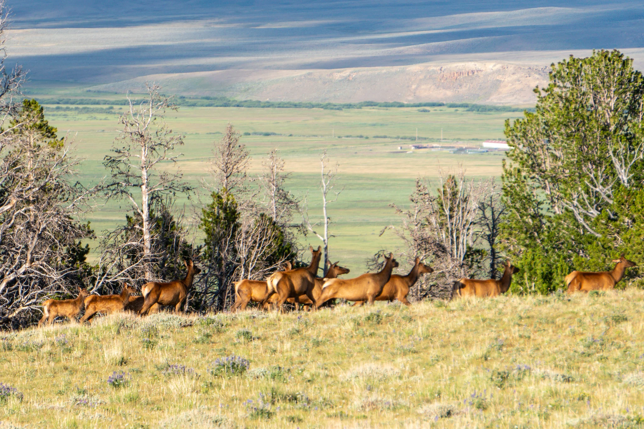
The peak sits at 11,000ft and I checked the valleys of Montana to the North and Idaho to the South and the skies looked clear. I made it halfway up the grueling climb and then noticed some dark clouds materializing nearby. After another chunk of elevation gain, I could tell the dark clouds and thunder were heading my way so I ducked behind a rock pile to see what it would do. I got rained on for a bit, the thunder grew louder and louder, and I could see lighting shooting down to the valley floor. I lucked out big time and the storm hooked North before producing a huge double rainbow that followed it up into Montana. I continued on to the summit and it did not disappoint! The view was out of this world and seeing the storm push North with a rainbow in tow was icing on the cake. I was on cloud nine until I realized I still had a crazily steep descent and a lot of miles to go to make it to camp. On the way down I found an ice cold spring that was not on any of my maps and soon after I rejoined a 4x4 road…a herd of at least 75 elk ran in front of me. I was overwhelmed and kept switching between taking videos, photos, and just enjoying the spectacle with my own eyes. Today was amazing. The final icing on top was when I arrived at my destination, two of my buddies already had a campfire going. Best day on trail yet!
This storm came out of nowhere when I was 2/3 of the way up to the summit of Cottonwood Peak.
I waited out the storm and was rewarded with this gorgeous double rainbow.
This elk belongs to the Ministry of Silly Walks.
Day 41, 27.8 miles to camp at marker 822.5
I was out of camp around 8 which impressed myself since I stayed up so late last night. After a few miles I took the old CDT which takes one steep drop to Deadman Lake instead of going up a hundred feet and then making a giant two mile gentle decline to the lake. I love the power of choice on this trail. I filled up my water from an inlet stream and then blasted up the big climb of the day. I retrieved water at the last spring before a long right mile stretch across a field with no shade. The afternoon heat was in full force and made this stretch brutal but I found some shade by some mining equipment about six miles in. I climbed around on a huge bulldozer and found that the cab was unlocked so I went inside and played with the levers like a 6 year old. I then scrambled up some rocks to another alt route that passes a pit of bison bones. I chatted with a couple out on an ATV ride and they topped me off with some water before I pushed on. After a down and up, getting even more water, I made it to the Red Conglomerate Peaks in time to watch the orange glow of the setting sun illuminate them and chomped down some dinner during the show. Afterwards I realized that about a mile up the trail I could've watched the spectacular sunset before crossing over the saddle. Oh well. I found a sweet hammock spot near the top with a great view of sunrise the next morning.
Deadman Lake.
Big toys for big boys.
The Bone Pit.
Red Conglomerate Peaks.
Day 42, 27.3 miles to Highway 15 and a hitch to Lima, MT.
The sunrise was underwhelming but I was up early to fly down the mountain and cross through cow land. All of the water sources had cow prints and sometimes cow pies floating in the water so I went farther down the trail as my thirst increased. I eventually got into the valley of Shineberger Creek and there was a good 100 cows that kept hiking upwards with me. They hit the fence and them seemed to start cornering me but luckily I have the ability to climb over fences. I got some photos of the mob as they stared accusingly at me. From there it was a quick hop back up to the actual divide ridge where it stayed for twelve miles. It was a hot, shadeless, waterless, and I wound up dipping down early on an alternate route to get water and rest in the shade. Then I speed hiked the ten miles down a gravel road hoping to catch a shuttle into Lima. I missed it so I threw out my thumb to hitch and proceeded to have the worst luck of my hitchhiking career; FOUR HOURS! At least clouds rolled in to keep me from getting roasted by the sun and they never dropped any rain. I was also treated to a nice rainbow and a sunset as I stood on the pavement for an eternity. My buddies Tailspin and Rafiki arrived and were a good luck charm since 15 minutes later, as the sun was almost gone, we landed a ride in the back of a pickup. When we got to town we scarfed down burgers at Jan's Cafe and then camped in a little park next to the gas station.
