
Section 6 is 122.2 miles long and runs from Highway 43 to Bannock Pass, the road to Leadore. July 27th - 31st.
Day 34, 23.8 miles to South Fork Sheep Creek.
The crew was moving very slowly in the morning while I was up and at em and eager to get hiking. I said I'll catch them later and scored a hitch up to the Highway 43 trailhead where I resumed my footpath South. The CDT follows some more snowmobile and ski roads for a bit before arriving at a long ridge with views of Squaw Mountain and another Pyramid Peak. The sun was shining but dark clouds accumulated and started to chase me down. After the day was fine, it had rained seven separate times! I bunkered down, chatting with Sea Lion on the phone, under a single tree on a ridge when the worst pour hit and it even hailed a little bit. After the rains cleared out I listened to some Dirty Heads and jammed out on my way down a steep slope. The sun was out and I was feeling great! I passed some hikers who told me one of their buddies saw smoke start riding from a spot where lightning struck and called it in to the fire patrol. Soon after I saw a double rotor helicopter flying overhead. I stopped to cook dinner at a river crossing and then crushed a few more miles before setting camp.
Mariposas have become the most common wildflower.
This tree for burned from the inside out.
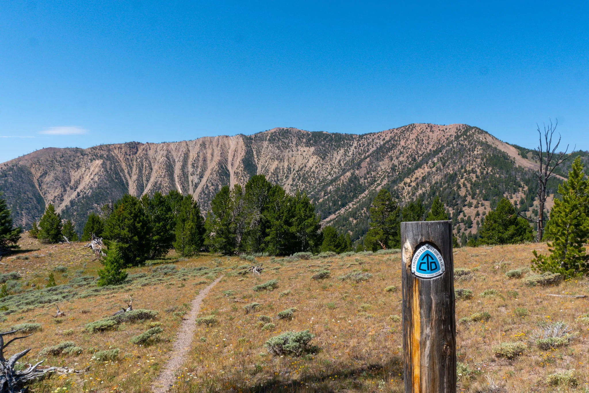
Big Hole Pass - hiking in two states at the same time.
One of the lightning strikes ignited a tiny fire, the fire team flew over to check it out.
More cabins! This one still has a roof.
Day 35, 24.7 miles to Rock Island Lake.
My hammock spot was so stealthy that three hikers walked passed in the morning and didn't see me, even though I was only 20 feet off trail. The day began with a climb up to a ridge alongside Pyramid Peak where I could see Squaw Mountain ahead and also look back to see West Goat Mountain in the Pintler Wildness. A short eight miles later and I was cruising passed Squaw Mountain and then dropped down into the gorgeous Slag-A-Melt Lake. I took about an hour break, went for a swim, and chatted with two other hikers named Seabiscuit and Ricky Bobby. They departed before me and I made a note that there was an ATV trail that led almost up to the lake. After a big looping turn into the next valley and up to the head of Big Swamp Creek, there was a pretty stream cascading down a rock-halfpipe. I took some photos and had dinner there but was even more impressed with the next valley which looked like it belonged in the Sierra's. Homer Youngs Peak sat commandingly across the way and a big rock pit sat in the middle, looking like the handiwork of a big glacier. Down in the bottom I made a snowball and then hiked up the other ridge. There was a steep downhill to the lake and on the way I saw an island chilling smack dab in the middle. I hiked faster hoping to get to the lake before sunset and I barely made it in time to swim out to it. I danced and yelled and enjoyed my private island but knew I should get back to shore before it got too cold. I also had the amazing campsite to myself where I built a fire, sewed my socks, and read my book before bed.
Pyramid Peak and Squaw Mountain.
Slag-A-Melt Lake. Ugly name but beautiful spot.
Nice spot for dinner, Big Swamp Creek.
Homer Youngs Peak.
See why they call it Rock Island Lake? I decided right then and there that I was going to swim to the island.
Space Jam Island under the stars.
Day 36, 26.7 miles to camp at Marker 698.
I debated going back to the island but remembered the water would be at it's coldest in the morning so instead I got packed up and went to crush some miles. The trail soon joined a road that looked perfect for ATVs and I thought that Rock Island Lake and up to the Sierra-like valley would be an awesome weekend trip. At my first water re-up I almost smacked my face on a big spider web as the owner was eating his breakfast. Further down the CDT you cross Hamby Creek and then hit a newly updated section that added about two miles of switchbacks to reduce a painfully steep climb. Next up was a gentle flat section where you could fly, so I did. I passed yet another abandoned and decomposing cabin by Berry Creek and then stopped for lunch at the crossing. The next valley had a quick and fast rain that only lasted ten minutes but cranked up the humidity for the rest of the day. I was planning to camp at a waypoint marked as an overlook but it was a totally exposed pass and really didn't have any views. I decided to go down to the next valley and I could see that the next ridge had an Easy facing cliff which would be a great place to catch sunrise. As I was climbing up the other side, a heavy rain hit accompanied by thunder and lightning. It stayed on the West side of the ridge while my East side became calm and produced a massive rainbow. When I crested the climb it seemed like crossing over into a fiery glow of hell. Thunder was loud and the setting sun painted the clouds an evil shade of orange. The trail does loop West before getting back to the East facing cliffs with good tree cover. It was a wild time being up there during the thunderstorm but I found a good safe spot in some dense trees.
Day 37, 26.5 miles to camp at marker 724.5.
I was too tired and cold to set a timelapse for sunrise but I was up in time to snap a few photos. Soon after hitting the trail I crossed the 700 mile marker and built another sign for the hikers behind me. The CDT soon drops off of the ridge to hit a tiny spring and then shoots back up a steep 800ft climb. Back on top on the actual divide the trail does a few crossings between lush green trees and blackened wastelands from fires. Each time there was an abrupt line where the fire stopped and the color scheme changed. I took a power nap in the afternoon and when I was checking my maps I decided that if I gunned it the next 10 miles, I could get to a Westward facing view point in time for sunset. I quickly packed up and started power hiking. At least the terrain was cooperative and allowed me to hit a very fast pace as I flew down to Lemhi Pass. There were a lot of information placards explaining the how it was a Lemhi Shoshone trail that the Lewis and Clark expedition came across. I wanted to read more and enjoy the view but I had an end-game in mind so I kept trotting along. I grabbed water at a spring at the bottom of the pass and then completely exhausted myself on the ridiculously steep 2 Mile climb up the South side. I made it to the viewpoint with minutes to spare and enjoyed supper as I watched the setting sun. It was also convenient that there were plenty of good hammock trees nearby.
Sunrise from my backyard.
Baby grouse. I'm happy to report that his mom did not attack me.

The old trail marking method was to chop “i” marks in trees and it looks like they were worried about you getting lost in this 50ft section.
Lemhi Pass.
Day 38, 22.5 miles to Bannock Pass and a shuttle into Leadore, MT.
I was on trail early hoping to get to town as soon as possible. The terrain today was pretty flat and followed a dirt road which allows for some nice speedy hiking. It was beautiful to follow the divide and haveviews on each side but the water carries were long and the sun was hot. We followed some sort of fence for almost the entire day and towards the end cross by some sort of radio tower. It had triangular radar dishes which I have never seen before. From there it was was a nice and gentle downhill to Bannock Pass along which I narrowly escaped more rain. Robert soon arrived at the pass and we waited for an hour with only a couple cars passing by. Luckily, two other hikers arrived and had cell service so they called Sam at the Leadore Inn who scooped us up. In town, I cooked my last mac-n-cheese instead of going to the extremely overpriced and mediocre bar/restaurant. I walked across the street to get a shower as a great sunset was going on but Sam informed me that's about am average sunset for Leadore. I set my hammock in the corner of the Inn's yard but then realized it was under a street light and next to the highway. The light and loud noise of traffic made me give up and I elected to spend my first night in this trip cowboy camping. I slept with the other ground peasants.
Goat Mountain.
Old-school zigzag fence.
Evil looking tower.

Not going anywhere for awhile? After 90 minutes of waiting, other hikers arrived with cell service so they called the town shuttle.
Leadore sunset.