

Section H is 148 miles long and runs from Cascade Locks to White's Pass. I broke it into two sections, H-2 is 65.2 miles from Trout Lake to White's Pass. September 8th - 11th.
Day 125, 15.6 miles to Killen Creek.
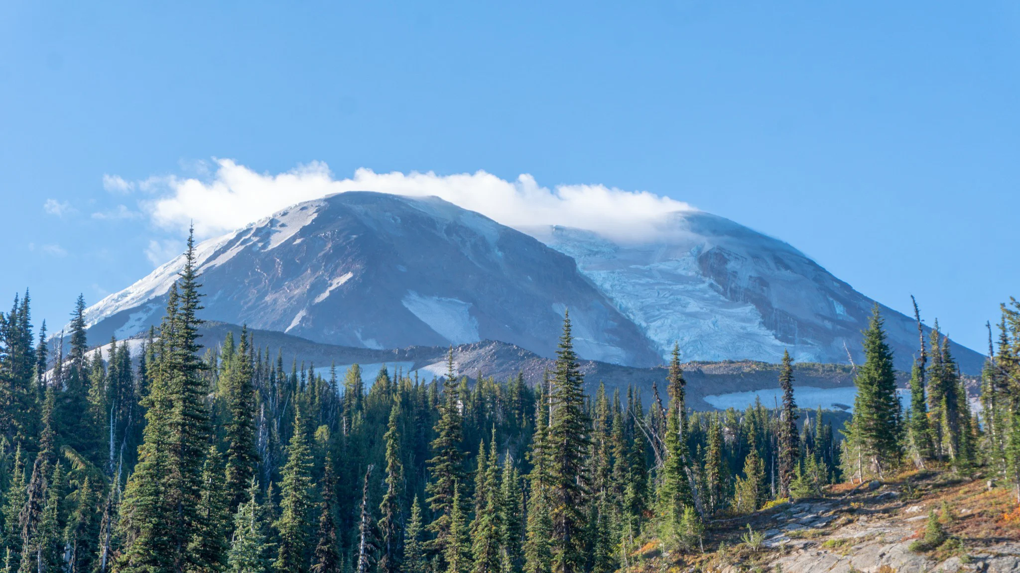
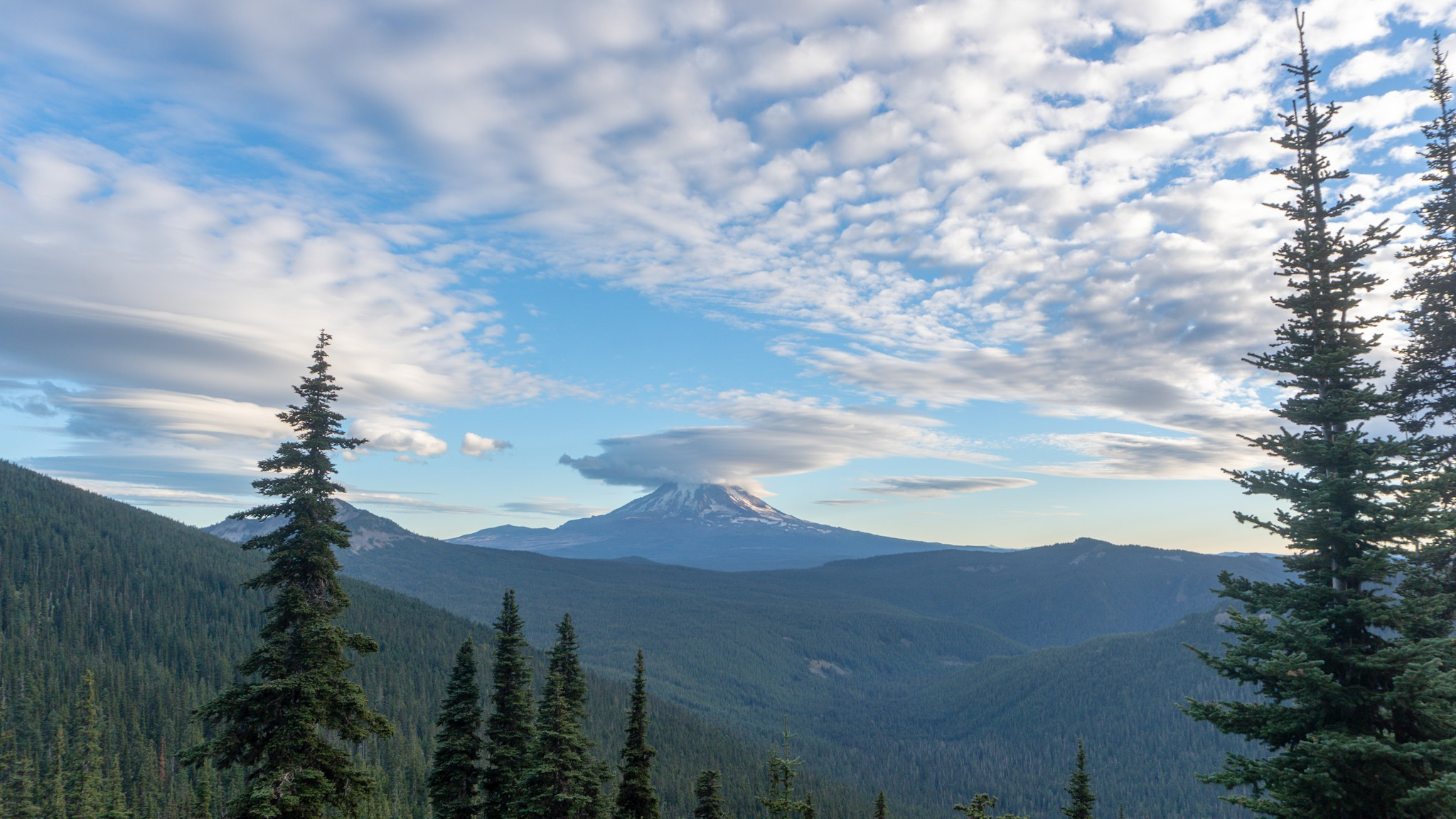
The rain stayed away and we enjoyed some breakfast beers in the tent as we waited for Station Cafe to open. Then Midge, Shark, and Squirrel joined us for a delicious brekkie accompanied with huckleberry mimosas. Afterwards, we did a food resupply at the general store for the short three day stretch. The 1030 shuttle ride was a bit too rushed so we decided to wait for the 12 o'clock ride. I finished a blog post and we hung out with some other hikers before packing up and loading into a pickup. The clouds stuck around and it still felt like rain was on the way. We flew up the first hill and on the way I saw a cool bird so I switched to my zoom lens. He flew off as I was doing so but then as soon as the lens clicked in place, a Fisher popped out of the brush and scampered around for a bit. The trail curved around the west side of Mount Adams and we got some good views of the southern White Salmon Glacier and then the northern Adams Glacier before clouds covered it up. We had a sketchy crossing over Adams Creek and then soon arrived at Killen Creek. There was allegedly a great view of Mount Adams but the clouds had socked it and the temperature was dropping. We scrambled in the cold to set camp when Shark popped up and said "hey, come check out this lake I found with a view of the sunset and Mount Rainier!" Sure enough, just past a line of trees was the described view. I loved seeing Mount Rainier. My first big hike was on the Wonderland Trail which encircles it and then I realized I was on that trail exactly two years ago. 4400+ miles of hiking later and I was back looking at that majestic mountain.


Fisher.

Fisher close up.

White Salmon Glacier on Mount Adams.


Mount Rainier. Two years ago to the day, I was wrapping up the Wonderland Trail, a 93-mile loop trail around the whole thing. It was my first big hike and it stirred up some feelings seeing the mountain again.
Day 126, 25 miles to Sheep Lake.
It was again cold in the morning but the rain continued to stay away and the clouds clear out. We got packed up and kept hiking north. We soon got to the bottom of the hill where Lava Spring resides. A strong flow of ice cold water bubbles out from under a huge pile of lava rocks and it was a great spot for second breakfast. The terrain for the rest of the day was pretty easy, gentle ups and downs and the blue skies returned. We entered the Goat Rocks Wilderness which we've heard was one of the most beautiful sections of the whole trail. The deeper we went into it, the more I agreed. There were endless hills carpeted with green trees, rocky cliffs, and colorful brush. Towards the end of the day we were on a ridge with one of the last views of Mount Adams and it was wearing a big cloudy hat. We got camp set and I captured a time lapse of the sunset.
Mount Adams.
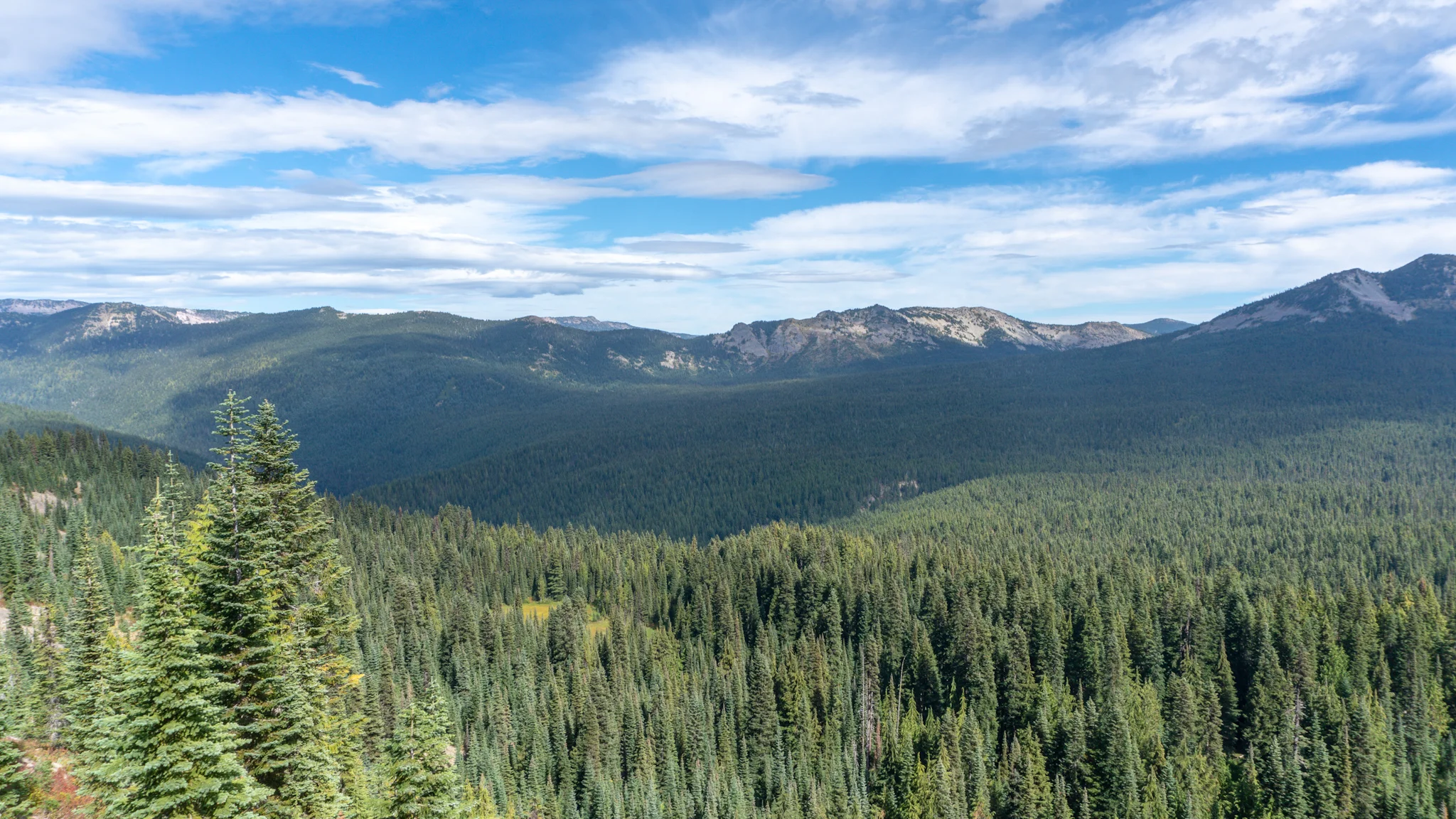
Goat Rocks Wilderness.


Day 127, 9.2 PCT miles and about 9 miles on the Goat Rocks reroute.
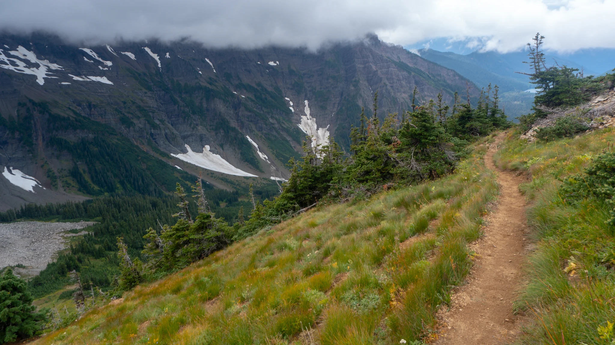
It rained during the night but relaxed to a foggy drizzle in time for us to get packed up. The rain came back as we made the first climb up Cispus Pass which borders Native American lands and there were lots of signs to make sure you knew it. We crossed a few streams that were swelling up with the rains and then had to cross a snow patch. We should have seen it coming since we were just below Old Snowy Mountain and it's name must have came from somewhere. We got to a junction which I believe was recently switched. The original PCT went up almost to the summit of Old Snowy and then back down the Knife's Edge Ridgeline, while a horse route stayed at a lower elevation with stable ground. Now the high route was the alternate but I was determined to take it even if the views were blanked out by fog. We reached the top and almost immediately the clouds broke. The views of the valleys below were absolutely stunning. They rivaled the Palisades in beauty. I was so thankful that the gamble to take the high route paid off. We ran into Moose, Shark, and Squirrel when the trails rejoined and we hiked along the lower section of the ridge as the clouds rolled in and out. The views were either amazing or non-existent. We then hit the Coyote Trail where the PCT reroute begins and it was obvious we were no longer on a trail that is graded for pack animals. It was steep and wet and felt like the Appalachian Trail. Google and Guthooks didn't have any maps available, so we were flying blind for the reroute and everyone agreed that the mileages the PCTA provided were way off. We trudged along as rain set in, fog hung in our faces, and the trail remained steep and slippery. We set camp near Lost Hat Lake and when the heavy rain returned it began flooding our tent site. I'm a novice with tents in the rain, I hammocked the whole AT, and maybe we just picked a terrible site, but I had to use my poop trowel to dig a trench to channel the water away. Luckily it worked. We were soaked to the bone, cold, miserable, and hoped the four miles to White's Pass would be easy the next day.
The video below is a short highlight reel of the magical day, here is an extended version


Looks like a hamburger.


North Fork Tieton River Valley from the Knife's Edge.

Coyote Trail was off to a good start.
Day 128, about 6.5 miles to White's Pass.
We again are unsure of the exact mileage but whatever length it was, it was again steep, wet, and miserable. At least we had a short break in the heavy rainfall to pack up our sopping wet gear and start hiking through the cold. We marcbed straight to Highway 12 without stopping for a rest or water or anything. We started hearing the rumble of the higheay but then the trail would make a turn and head away from it. Then, about a half mile from the trailhead, there was a large ford across Upper Lake Creek and I debated walking right through it since my socks and shoes couldn't get any wetter. But they could still get colder so we went a good bit upstream to cross on a log. We got a hitch in a Jeep very quickly and met Moose and Midge at the Kracker Barrel. It's a gas station, not the country cooking restaurant chain. They sold us on staying at the lodge next store instead of hitching into the nearby town of Packwood. Twizzler, Pickle Pacer, and two new friends, Tahlia and Manor also joined in on the deal for a cozy lofts condo in the lodge. Twizzler and Pickle Pacer were already in Packwood and brought up a bunch of food and some booze. We had mulled wine as Moose cooked up a banging spaghetti and chicken dinner. Our unit had a boot dryer, which was a godsend because my new waterproof shoes would've taken forever to dry out. We then sipped on beers and watched the classic cinematic masterpiece The Big Lebowski. It was a terrible start to the day but had a great finish. It was too wet for photos during the hiking part and my streak continued with forgetting to take photos of towns and rest days.