

Section B is 100 miles long and runs from Warner Springs to the I-10 bridge at Cabazon. May 15th - 21st, 2018.
Day 8, zero-Day at Warner Springs.
We took an extra day off to relax and do some camp chores; bucket shower, read, redistribute the down in my sleeping bag, blog, and go to the post office to get our food drop that we shipped from San Diego. We syphoned off enough to make it to Idyllwild and then shipped the rest up to Aqua Dulce. Also, we took the rest day because our feet were really sore. Our faction of hiker friends from Scout and Frodo's departed in the morning but were replaced with another faction from S&F's. It was nice catching up with everyone. Nhandi bought a new pair of shoes since her Keens were too hot and ill-fitting which lead to blisters.
Day 9, Warner Springs to Mike's Place, 17.4 miles.
We were out of Warner Springs early and plunged down into the pasture, which still held lots of fog. The trail was heading upwards all day and we stopped for lunch under the shade of a giant rock on a small summit. The new shoes felt great but the damage had already been done from the Keens, so Nhandi elected to pop the worst blister and hike the last stretch in her sandals. By the time we got to Mike's Place, all the blisters were looking terrible, some popped and collected dirt under the skin, so we stayed at Mike's to sort it out. The caretaker, "Off Trail" was super nice with getting a tub of water to soak her feet in, letting us pick through the first aid kit, and then he began making pizza from scratch and firing them up in a brick oven. More of the crew arrived and Chris and Minji helped me do some surgery on Nhandi's ailing feet.


“Welcome to Mike's Place: The tendency nowadays to wander in wilderness is delightful to see.”
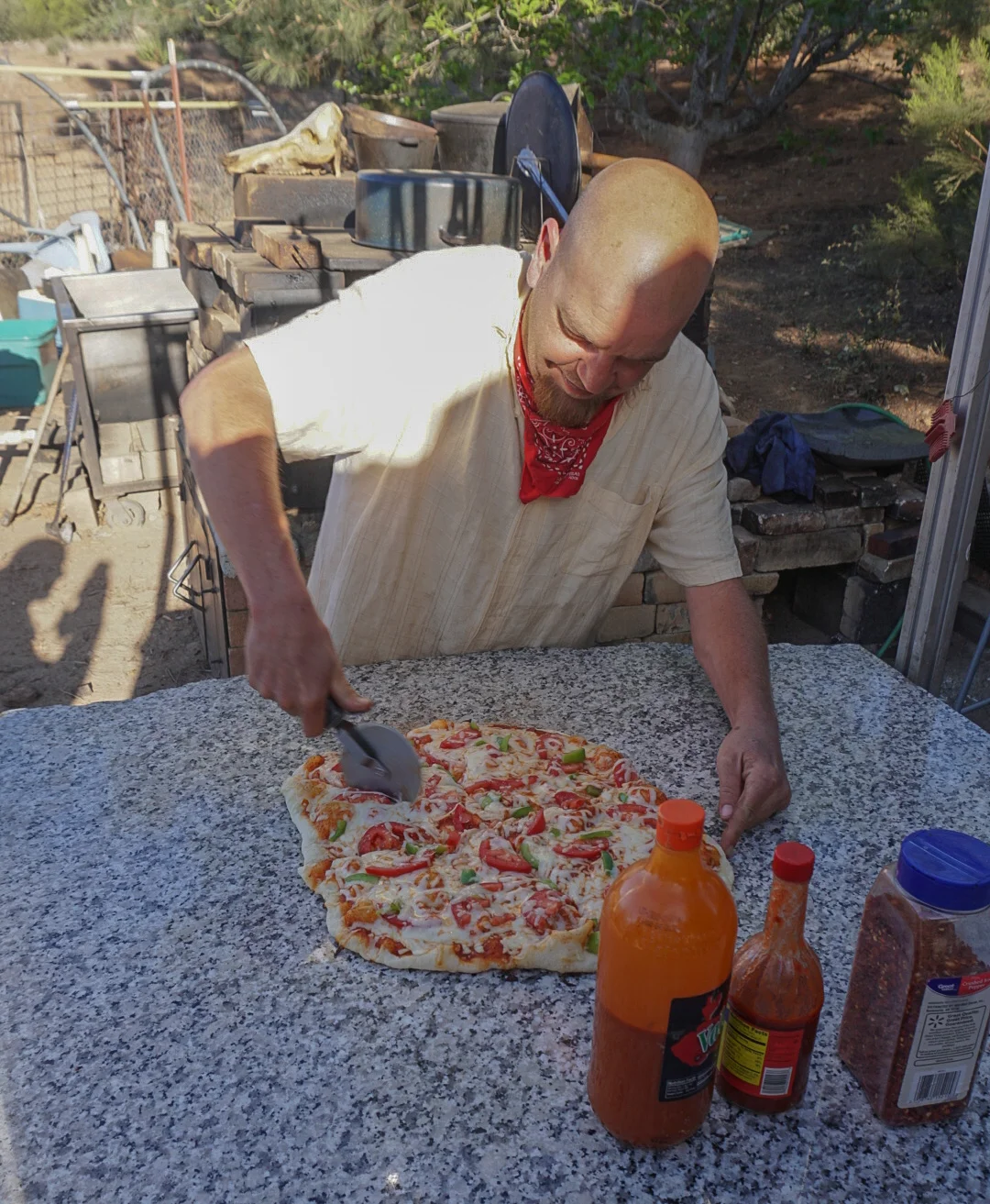
"Off Trail" cutting up some fresh brick oven pizza for us hikers, you da man!
Day 10, Mike's Place to camp at Mile 142.3, 15.4 miles.
We had a lazy morning as we wanted to give the surgery feet more time to rest, I tried to convince Nhandi that we should take a Zero-Day there to let her feet heal up but she insisted otherwise. She is a champ! It was 24 miles to Paradise Cafe where she could hitch to Idyllwild and really get a chance to recover. So off we went, taking breaks every few miles to let the feet air out and prevent the bandages from peeling away.

Yucca about to pop.

Horned Lizard.

Not all water sources are created equal.
Day 11, Camp to Camp, 23.5 miles.
We were up at 6am and hit the trail shortly after, soon arriving at Muir Woods, a nice little rest stop right off trail with a tiny free library, shade awning, out house, and some quotes from famous transcendentalists. At Highway 74, Nhandi and I parted ways as she went to Paradise Cafe to rest her feet and camp for the night, while I went on to hike up to where the trail had a fire closure and we would rendezvous in Idyllwild on Friday. The trail shot up 2,000 feet and followed a ridgeline with amazing views on both sides. I kept piling miles on the day and eventually found a great spot to cowboy camp under a huge boulder.

We met Mary, who runs the lovely rest stop "Muir Woods" at mile 145 and she had a German Shorthair Pointer named Scout! Same name and breed as the doggo I had growing up.

Approaching the fire closures, had that Tim Burton feel.

Recovery in progress.

A wild fire a few towns over sent some smoke my way but led to this great picture after I climbed up a rock tower.
Day 12, 2.8 PCT miles + 7.2 alternate trail miles.
I was on trail at 6am and was the first to drop down the Spitler Peak Trail which descends almost 1,000 feet in the first mile. It's trailhead terminates on a desolate road with almost no traffic, so after 2.6 miles of that road walk I was happy to get a hitch to town. Nhandi nabbed the last room in Idyllwild and we relaxed all day, rested the aching legs, got dinner at the nearby Mile High Diner, then watched LotR: Two Towers.
Day 13, 5.5 PCT miles + 4 alternate trail miles.
We walked to town and got a food resupply for the next 100 miles. I got new insoles for my shoes, then we went to Mayor Max's birthday party which had free pizza, ice cream, and cake. Also, Mayor Max is a dog, yup, Idyllwild has a dog for it’s mayor! After eating, we scored a hitch to the trail head, but she took us to the wrong trail head which cuts off a few miles of the PCT after the fire closure. Luckily, another trail creates a perfect loop for that section, so we could rejoin the PCT at the very edge. That night we ran into a gaggle of our friends from Scout and Frodo's who already had a campfire going so that was where we camped for the night.
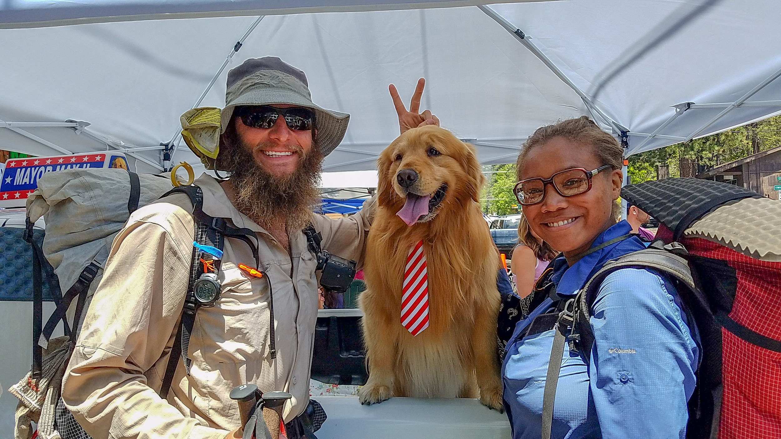
How many people can say they gave the mayor some bunny ears during a photo op?

Looking back towards Tahquitz Peak.
Day 14, 17.8 PCT miles + 5.2 miles up and back to San Jacinto Summit.
We we're on the trail at 3:30am with plans to hike three miles to the San Jacinto summit trail and then the 2.6 miles to the top in time for sunrise...but we did not make it. A combination of the lack of a good brekkie, a 2,500 foot ascent, and the oxygen levels at 9-10 thousand feet all slowed us down and we were late. But the views were absolutely stunning from the peak and we had the place all to ourselves. The rest of the day was a long descent down to the valley floor, over 9,000 feet below. After the grueling drop, we were greeted by relentless winds and were beyond happy to reach the shelter of the I-10 bridge, which also had freshly stocked Trail Magic with sodas and snacks.
We concluded Section B halfway through Day #15 (May 21st) after finishing the descent and crossing the super windy desert floor.

I had to lug the sign up a 10ft tall boulder to be on the tippy top.

View from San Jacinto Summit.

Crossing the valley floor

So long Section B! San Jacinto in the background