
Section 10 is a lengthy 165.1 miles long and runs from Highway 26 to Highway 28. This includes the stunning Wind River Range so the section will be broken up into a couple posts.
The first is 69.3 miles long and runs from Highway 26 to the start of the Knapsack Col Alternate Route. August 14th - 16th.
Day 52, 18.1 miles to camp at marker 1117.4
I had some terrible sleep being indoors with stuffy air and stiff sheets. I was up early and first in line at the laundromat which was tardy in opening it's doors at 7am. So I went next door to the has station to get a donut and admire their obsession with Jackalopes. After doing my laundry and working on the blog I returned to the motel and wrangled up Newt and Flaming Hot to get breakfast at a nearby diner. We saw a few other hiker friends walk by and we laughed about how locals must see us as an infestation. We got checked out and found a nice hangout area behind the motel, next to the river, with a picnic table and some shade. I went to get my massive food resupply of seven days to cover a 165 mile long stretch, through the Wind River Range and down to Highway 28. I got back to our hangout spot, sorted the food, and began to work on the blog but was soon interrupted by an excited Newt. He had went to the gas station to get some snacks and a former CDT thru hiker, Didgereedoo, offered him a ride back up to the trail. When hitches like this present themselves, you must take them. At the trailhead, Newt and Flaming Hot took off but I needed a few minutes to stash my pants, and eat some leftover pizza from Rock Noon that I was packing out. The trail then followed gravel roads for a long bit and the day was kind of boring. I caught up to Meet and Flaming Hot but they soon set camp and I wanted to squeeze in a few more miles. As I was setting camp, I remembered that some comments mentioned this is the area where they relocate problem bears from Yellowstone. I would have to be extra careful with my food storage tonight.
Jackalopes.
Some old mineshaft in the middle of town.
7 day food carry to cover 165 miles!
Day 53, 30.3 miles to marker 1147.7
I woke up and had a relaxing and lazy morning waiting for my friends to catch up. I pre-made some wraps like it was a lunch to take to school and then did some stitching to my shoes. They had crossed 600 miles and it was showing, the side-mesh was starting to rip away from the sole. When I could wait no more, I hit the trail and made it about 6 miles before stopping at a creek to fill up on water. That is when they caught up and we hiked together for a little bit until they stuck to the official route and I went to take a 4x4 alternate that I heard good things about. It paid off, I had some great views and saw a lot of antelope running in a lower valley. I got back on the real trail, skipped a stream or two because there were cow pies everywhere, and then stopped for my second break at Lake of the Woods. I was thinking about a swim but it was a bit too cold with the cloud cover. Newt and Flaming Hot caught up right as I was putting on my pack so we parted ways. They were planning to take a long side trail and then hitch to the town of Pinedale which cuts the 165 mile food carry in half. But since I had to make it to Rawlins I didn't have time for all that. So we said goodbye. I decided to quicken my pace because the clouds seemed like they would be part of a fantastic sunset. Gunsight Pass was 10 miles ahead so I should be able to make it up there in time. When I flew past an older hiker, he started to tell me about a great campsite in 4 miles but I told him I was going 10 milea. I could see that it blew his mind. There was a lot of open meadows that I crossed and my legs were burning on the final climb but I was rewarded with a crazy orange sunset behind the silhouette of the Grand Tetons. It was worth the effort. I slowly night hiked my way down back to tree cover, cooked dinner, crossed Roaring Fork River, and set camp.
Antelope.
One last view if the Tetons.
Lake of the Woods
From the bald just above Gunsight Pass.
For real this time, last view of the Tetons!
Day 54, 20.9 miles to the Knapsack Col Alternate Route.
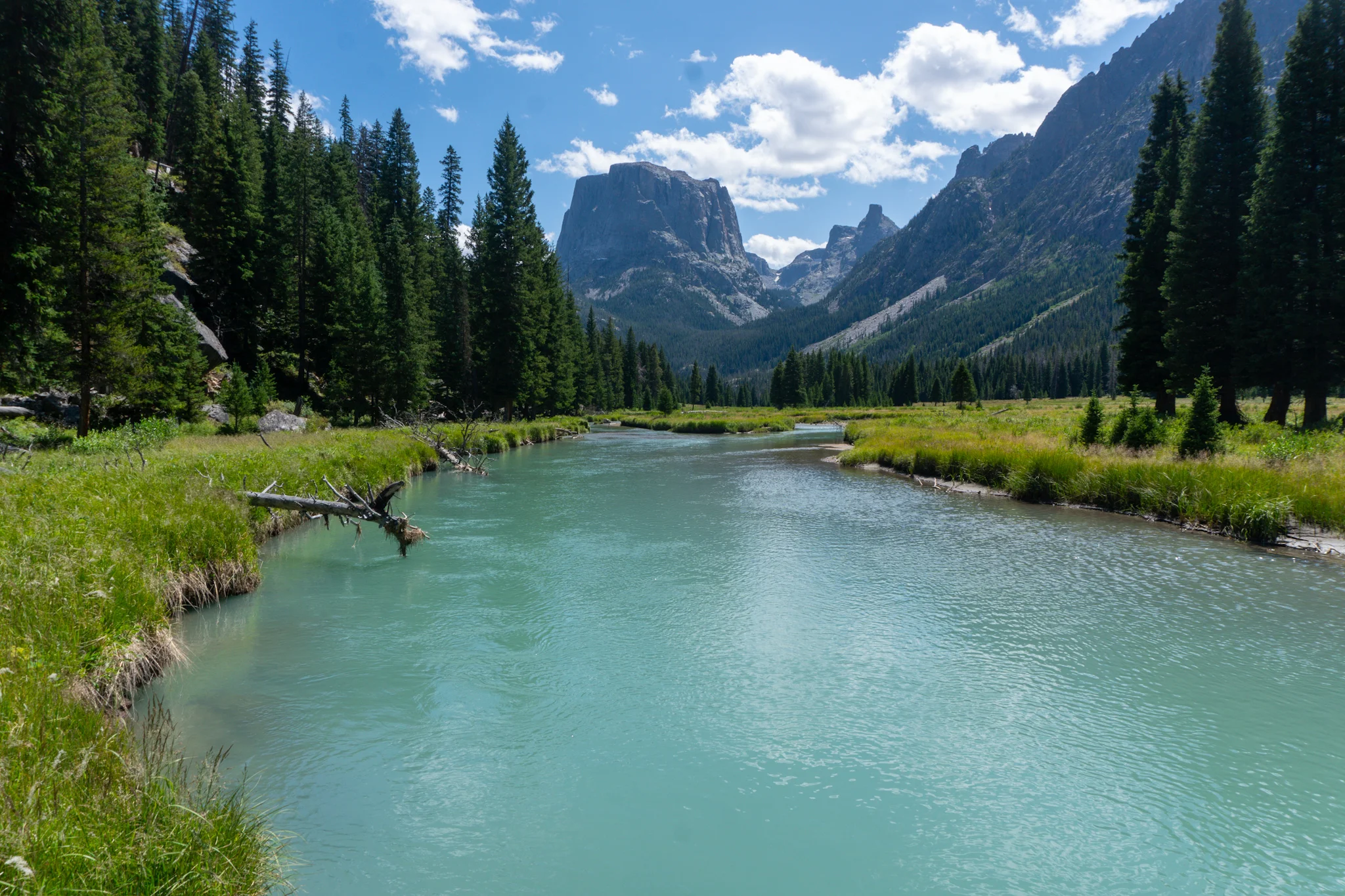
It was a short and easy morning to Green River Lakes, the beginning of the Wind River Range. I could see Squaretop Mountain and was happy that there was a cow gate before the valley which created the sense of actually entering the Winds. There were some decaying old cabins in the valley and I went across the bridge to the campgrounds, checked out the lodge, and then had lunch on the beach as I soaked in the view. I could not believe how green the water was and how surreal the mountains looked. I got back on trail while follows the Green River for a few miles and attempted to go for a swim but the water was frigid. I moved slowly as I took tons of photos of the massive Peaks and rock formations before shooting up 20 switchbacks and entering the turnoff to the Knapsack Col Alternate. I checked the USGS maps and planned to camp at the very edge of the tree line which thankfully had some large pines to hang my hammock from. On my way I came across a huge porcupine but he was camera shy and waddled away from me.
Lunch Spot: Green River lake and Squaretop Mountain in the back.
The Green River was indeed very green.
Trees grow in the darndest places.